

The Power of Geography: Chokepoints and Fragility of Power.
How a handful of routes control trade, energy, and the balance of global power.
The relationship between land and politics appears in many domestic issues. Disputes arise over property taxes, landfills, zoning, strip malls, water rights, and student housing. States face debates between green space advocates and real estate developers, political parties over district lines, and differing views on nuclear waste disposal.
Geography fundamentally shapes how power operates and is contested, both globally and locally. Interactions among states show that geographic constraints concentrate and challenge power. Recognising these patterns is essential to understanding how territory drives political and economic outcomes.
There are more national groups than territorial states. Existing territorial states do not always match the aspirations of thousands of groups. A state is a political entity with defined borders, a permanent population, government, and sovereignty. A nation is a group of people who share a common culture, language, history, and sense of identity. The number of sovereign states may rise as boundaries change by war, self-determination, negotiation, arbitration, or sale.
To further understand these forces, analysts examining geographical factors in world politics focus on "the geographical consequences of political decisions and actions, the geographical elements that were considered during the making of any decisions, and the role of any geographical elements that influenced the outcome of political actions." This builds on earlier discussions of how geography intersects with political outcomes.
In examining these dynamics, it is helpful to recognise that the primary actors in political geography correspond to those in world politics, encompassing states, nations, intergovernmental organisations (IGOs), and non-governmental organisations (NGOs). These spatial dimensions of international politics are fundamental to the discipline and help frame the next concept. Political geography is therefore defined as the study of the geographic forces that shape world politics.
Chokepoints: Mechanisms of Strategic Control
Throughout history, controlling key maritime routes has determined access to markets and strategic advantage. As we turn to chokepoints, it becomes clear that these waterways and transit nodes shape global trade and the military strategies of major powers. Their control exposes vulnerabilities, making neighbouring countries more susceptible to threats, and underlining chokepoints as critical levers of influence.
The term 'chokepoint' typically refers to a point of constriction or blockage within a system, network, or process. In the context of geography and geopolitics, a 'chokepoint' is specifically a narrow passage or location, such as a strait or Canal, through which the movement of goods, resources, or people is forced to pass. This makes it a critical and potentially vulnerable part of global systems, subject to strategic control and risk. The concept is also used across fields like shipping, logistics, engineering, security, military operations, and labour organising. Different communities of practice may identify significant points of constriction in various contexts. The most apparent chokepoints are geographic sites characterised by narrow passages.
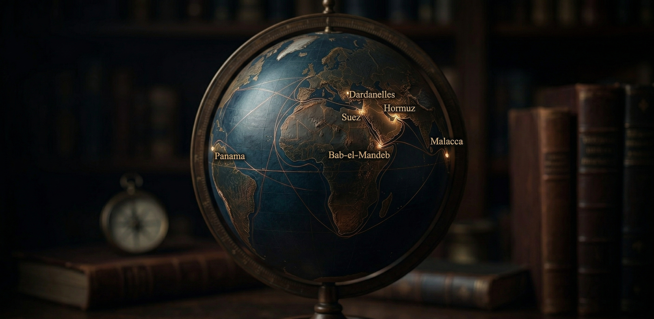
Chokepoints restrict the flow of vital resources, focusing economic, political, and military competition. Their narrowness and heavy traffic make them vulnerable: disruptions can bring entire systems to a halt. Hidden or obvious, chokepoints like ports, cables, and pipelines mark sites where flow control means power. States and other actors seek control of chokepoints because of their outsized influence on larger systems. Securing authority for these projects and shifting power at the national, regional, and global levels. Control over chokepoints is a direct means of shaping international relations.
While established powers seek to use chokepoints for coercion and control, their meaning and influence are contested and negotiated. Chokepoints represent relationships within complex networks: they embody both opportunity and vulnerability for those seeking to shape flows of power. Chokepoints compress both time and space, influencing not just flows but also broader possibilities. They demonstrate how physical constraints affect the tempo and scope of change, limiting both present and future options in politics, trade, and society.
Every day, chokepoint dynamics challenge existing strategies about global movement and security. The growth of megaships needs infrastructure changes, environmental adjustments, and special pilot training for tight waterways (Carse in this volume). Pragmatically (Middleton in this volume), local navigation can disrupt formal logistics and geopolitics. Ethnographic work on chokepoints can build on big-picture analyses and show new views from the margins (Valdivia in this volume).
Case studies-
The Strait of Hormuz: Oil and Immediate Power
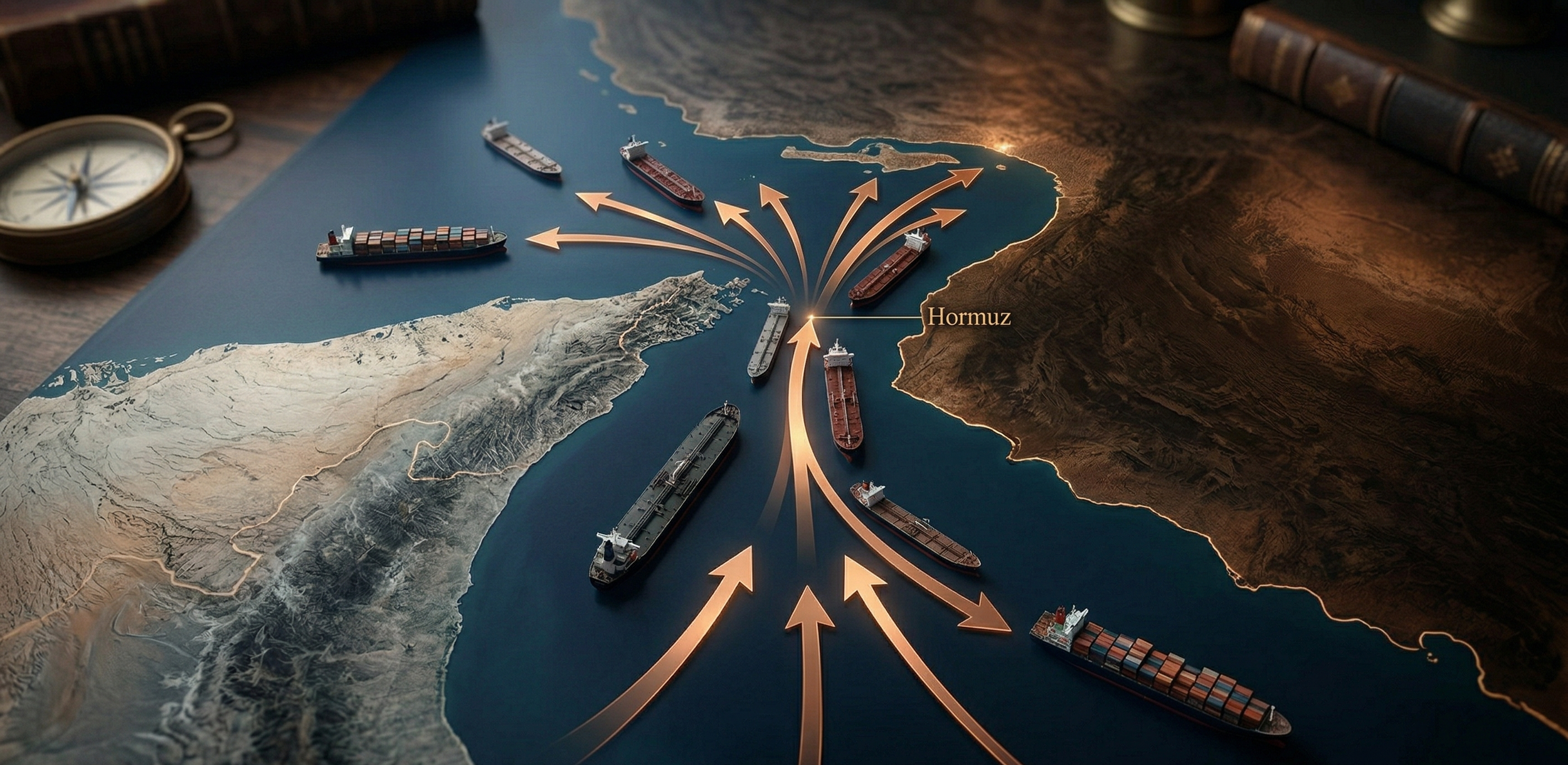
The Strait of Hormuz, a vital maritime route, connects the Persian Gulf to the Arabian Sea and the Indian Ocean. It is central to the global oil and gas trade. About 21% of the world's petroleum liquids pass through daily. The Energy Information Administration says it accounts for almost 40% of global oil exports. Any disruption would heavily affect the global economy. Heavy ship traffic underscores its importance to nearby countries like Iran, Kuwait, and the UAE, as well as to global markets. The Strait is key in politics, especially with ongoing tensions involving Iran, the US, and the Gulf states. Its daily oil flow proves its energy and geopolitical value.
The Strait of Hormuz frequently faces security threats, including tanker attacks and piracy. These add complexity to regional security. Problems like theft make navigation and safety harder. The Strait’s importance is not just economic; it is crucial to global energy security. This concerns the foreign and security policies of many countries. A deep understanding of its geopolitical and strategic dynamics is vital to ensure steady international trade in the future.
The Strait's central section is narrow, where the waters of the bordering nations meet. International maritime law and the UN Convention on the Law of the Sea govern this area. The central part is north of Oman's Musandam Peninsula, between Oman's Great Quoin Island and Iran's Larak Island. Only here do the territorial seas intersect. The Strait ranges from 35 to 60 miles wide, dividing Iran to the north and the Arabian Peninsula to the south. South of the Strait, Oman borders the Strait to the north; the south of the UAE's maritime area spans the Persian Gulf and the Arabian Sea. The UAE has the Persian Gulf's second-longest coastline, after Iran. The Strait also borders Iraq, Kuwait, Saudi Arabia, Bahrain, and Qatar. Dependency on this chokepoint is huge, especially for oil-importing Asian states such as China, India, Japan, and South Korea.
You can drop a plumb line through more than two millennia, since the Persians established forts and seaports to control the narrow chokepoint. For over two millennia, since the Persians established forts and seaports to control this narrow chokepoint, the Strait of Hormuz has remained a focal point of global attention. It continues to play a central role in sustaining global energy supplies and maintaining stable oil markets: the East and the Indian Ocean.
The Strait of Malacca
The Strait of Malacca is among the most important shipping lanes today. Its geopolitical importance goes back 400 years. For centuries, it linked the Indian and Pacific Oceans. Regional and global powers have repeatedly taken control. In 2011, over 60,000 vessels carried hundreds of thousands of containers, moving about a quarter of the world's goods, like oil, Chinese goods, and Indonesian coffee.
Approximately 35 per cent of all oil containers carried by sea pass through this Strait from the Middle East toward China, Japan, South Korea, and the Pacific Rim. In 2011, it became the key chokepoint in Asia's oil trade, handling an estimated 15.2 million bbl/d. flow in 2011, compared to 13.8 million- bbl./d. in 2007. Crude oil accounts for about 90 per cent of flows, with the remainder comprising petroleum products. Due to the Strait’s low waters (at 25 meters or 82 feet), the passage of larger oil tankers currently takes place in the Lombok, Makassar, Sibutu and Mindoro Straits. And its narrowness, at only 1.5 nautical miles, creates one of the most important traffic chokepoints in the world here.
In 1819, before the Anglo-Dutch Agreement of 1824, the British East India Company established its first trade station on the Strait of Malacca. Over time, the region developed into a major trade port. By 1867, the Strait of Malacca had become a significant geopolitical hub, marked by Singapore’s declaration as a British Crown Colony.
More recently, the Strait of Malacca has served as the main transit route, supplying vital goods to fuel the rapidly growing economies in Asia. Of the 87 million barrels of oil produced per day in 2011, approximately 15.2 million barrels were transported through the Strait of Malacca, the shortest sea route between African and Persian Gulf suppliers and Asian markets. This figure corresponds to approximately 19 times the oil passing through the Panama Canal and 4 times the oil passing through the Suez Canal in the same period.
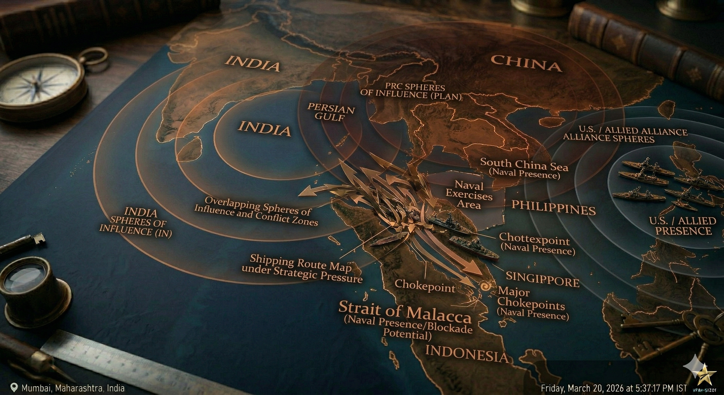
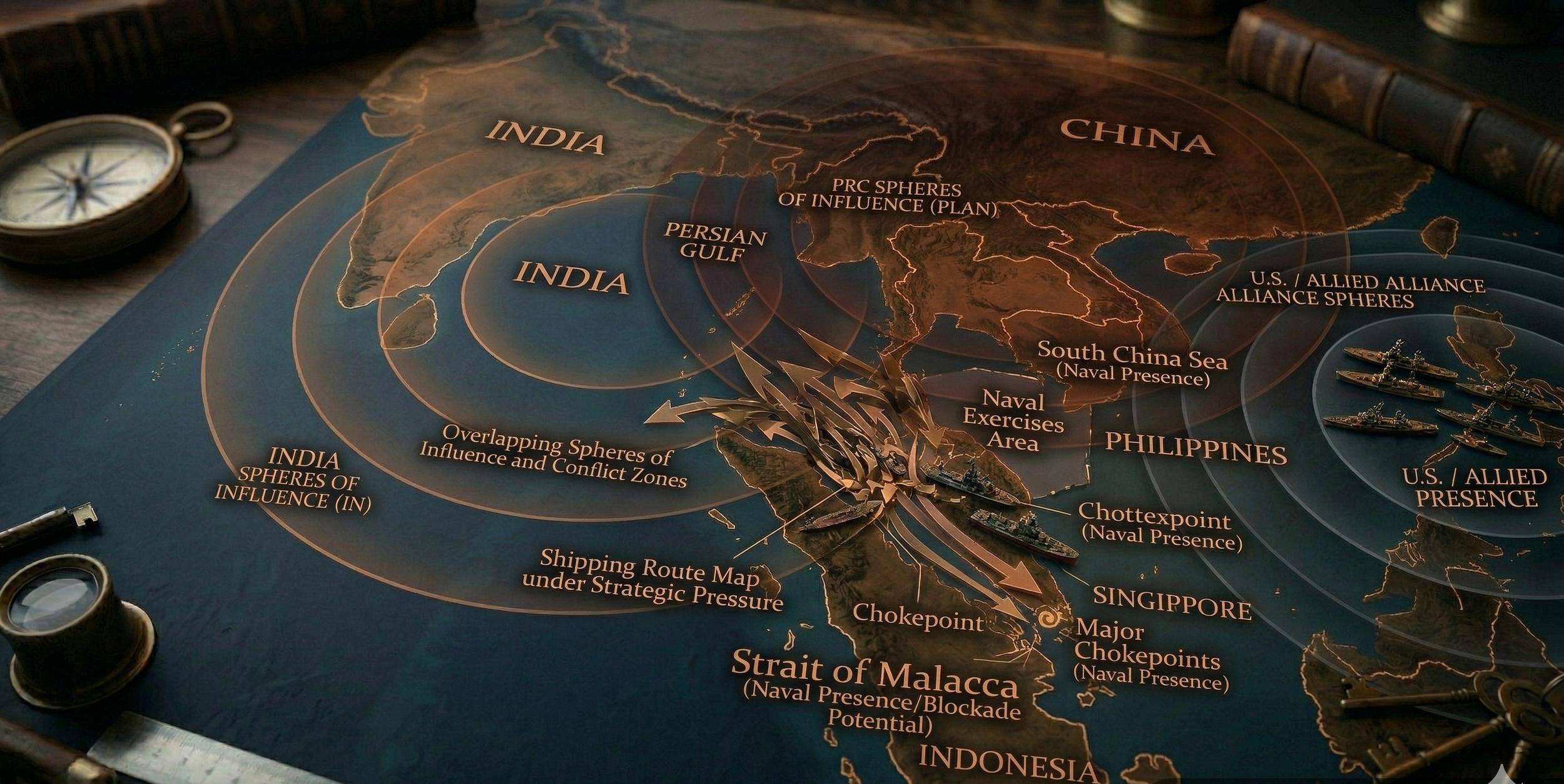
Approximately 60 per cent of the world’s maritime transport passes through the Strait of Malacca. The Strait is home to more than 150 ships a day, mostly tankers from China and Japan. In this sense, the Strait of Malacca is part of the transport route for approximately 25 per cent of the oil transported between the Middle East and Asia. With the growth in the populations and wealth of China and other regional powers, this ratio is rising steadily. The Strait of Malacca plays a key geographical role for the entire Indo-Pacific region. For this reason, many countries in the region, including China and even the USA, are dependent on the Strait of Malacca.
China is heavily reliant on energy sources that drive its long-term growth. China has to ensure the availability and sustainability of energy sources. To this end, it seeks to safeguard energy transit routes, as it is a major energy importer from the Middle East and the Pacific Ocean. Maritime trade has become a very important factor in the modern Chinese economy, which is why China seeks to ensure the safety of sea lanes.
State-owned Chinese development projects have extended their control in the region by the proposed completion of the Myanmar-China Oil and Gas Pipeline in 2013. This pipeline created two parallel oil and gas pipelines that stretch from Myanmar's ports on the Bay of Bengal to Yunnan Province in China. As explained by the US Energy Information Administration (EIA), the construction of this oil pipeline “will be an alternative transport route for crude oil imports from the Middle East to bypass the Strait of Malacca potentially. The oil pipeline capacity is expected to reach about 440,000 bbl./d.” and will extend the zone of control of the Chinese umbrella. This Chinese umbrella is structured in several aspects: military, economic, and political. From an economic perspective, the investments undertaken by Chinese state-owned companies in the region aim to achieve more direct control, as 75 per cent of China’s present crude oil imports originate in the Middle East.
China continues to rely on the Strait of Malacca for the majority of its energy imports from Africa and the Middle East; 77% of China’s total oil imports currently are brought in via this shipping lane, and that could drop to 54%, even as the volume shipped through the Strait continues to rise. China's naval strategist described the energy value well in his words; “Strait of Malacca is a blood to breathe and live a life itself.” On the other hand, the Strait of Malacca has been threatened by pirate attacks, involving both state and non-state actors. China is well aware of this weakness in the Strait; therefore, it can be threatened by other states disrupting its supply. China's principal fear is the blocking of the Strait of Malacca. China wants to defend these water lanes from piracy, and it is not for China but for every state to have fear of pirate attacks that depend on the Malacca Strait.
The Suez Canal: When The World Stops Moving
Between 1859 and 1869, the Suez Canal was owned by the Egyptian government and excavated and managed by the Suez Canal Authority. From its completion in 1869 to August 2015, the Canal served over 50 ships a day and was a critical shipping artery. The Suez Canal was too narrow to accommodate two-way traffic. Ships, in convoys, passed through the Canal. It took a ship between 12 and 16 hours to pass through the Canal. Since the 2014 expansion project, the Canal allows only regulated two-way traffic executed in shifts. The Suez Canal connects northern Africa and southern Asia via the Isthmus of Suez, linking the Mediterranean Sea and the Red Sea. The Canal’s opening allowed the first saltwater flow between the Mediterranean Sea and the Red Sea. The construction of the Aswan High Dam across the Nile blocked the naturally nutrient-rich silt from entering the eastern Mediterranean at the Nile Delta, reducing freshwater inflow. Since the 1880s, exotic species from the Indo-Pacific Ocean have been introduced into the Mediterranean via the Canal and have become a major element of the Mediterranean ecosystem.
The Suez Canal is one of the world's most important chokepoints. It operates as a maritime shortcut, avoiding the South Atlantic and Southern Indian Oceans, which reduces the journey distance by 8,900 kilometres on a trip from the Arabian Sea to London. Travel time was reduced to 10 days at 37 km/h or 8 days at 44 km/h compared to the Cape of Good Hope route. Around 12 per cent of global trade passes through this strategic Canal, which accounts for 20 per cent of global marine freight volume and 22 per cent of container traffic. It has been popularly portrayed as a “sea transportation shortcut between the east and the west” and a “world throat-cutting seaway channel.
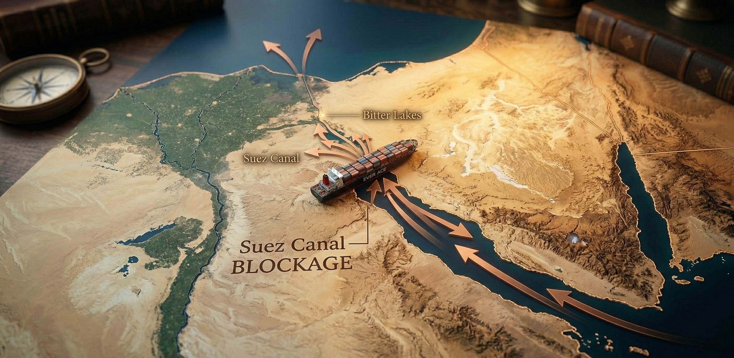
The Suez Canal alone accounts for nearly 12 per cent of global maritime trade. This includes a substantial portion of the world's seaborne oil, with millions of barrels of oil and petroleum products passing through the Canal daily. The Canal also plays a key role in the transport of liquefied natural gas (LNG), rendering it essential for global energy markets. The Canal is pivotal for the transport of a wide array of goods. This includes not only energy products such as crude oil and natural gas, but also consumer goods, automotive parts, grains, and other bulk and containerised cargo. For many countries, especially those in Europe and Asia, the Suez Canal is essential for guaranteeing the timely delivery of goods and energy resources. It supports international trade operations, enabling economies to import and export goods more efficiently. A disruption in the Canal could lead to delays, higher shipping costs, and broader economic repercussions worldwide. The Canal's importance was highlighted by the Ever-Given incident in March 2021, when a container ship blocked the Canal, causing a significant backlog of vessels and exposing the fragility of worldwide supply chains.
On 23 March 2021, the containership Ever Given ran aground in the Suez Canal. The vessel’s bow got lodged in the eastern bank of the Canal. The Ever-Given measures 400m long, has a beam of 59m, and a capacity of over 20,000 TEU. Since the 2016 investment program, large sections of the Suez Canal have been able to accommodate two-way transit. However, the incident occurred in the southern section of the Suez Canal, which has only one navigation lane, resulting in the complete blockage of all transits. The incident occurred due to a loss of manoeuvrability caused by strong tailwinds and a sandstorm. The containership was sailing around 13.5 knots, while the normal speed for Canal transit is 7.5 to 8.5 knots. The vessel did not have a tugboat escort through the Canal, while the two ships immediately ahead of it did, though escorts were not required.
There was a traffic jam on both entries of the Canal (the Mediterranean and the Red Sea), where more than 430 ships were forced to wait. Each additional day of delay tied up an additional 0.5% of global shipping capacity waiting in queues. For shipping lines, this resulted in time costs for vessels, revenue loss, and capacity loss. The backlog of ships in the Suez Canal was cleared on 3 April. On a normal day, some 50 ships pass through the Suez Canal (18,840 ships in 2020). To clear the backlog, peaks of 100 transits per day or more were recorded, pushing the Canal’s transit capacity to the limit.
The disruption of trade and supply was immense as several shipments were delayed, particularly European imports from Asia. The blockage held up USD 9 billion in global trade each day, leading to time costs for goods (i.e., economic depreciation, technical depreciation, and opportunity costs of capital). The Suez blockage further exacerbated a constriction in shipping capacity and equipment, and consequently led to some deterioration in supply chain reliability. The Suez Canal Authority's revenue loss was in the range of USD 100 million. Revenue linked to the Suez Canal transit fees had reached USD 5.6 billion in 2020.
On 29 March, the containership was refloated and towed away to the Great Bitter Lake. Smit Salvage, a subsidiary of the Dutch Boskalis group, assisted in refloating the vessel on a ‘no cure no pay’ basis. This included the deployment of large dredgers and backhoe cranes to remove more than 30,000 cubic meters of sand from around the ship’s bow, while 11 harbour tugs and two powerful seagoing tugs were used to free the vessel.
Therefore, the Suez Canal is economically vital for reducing transportation costs and time, thereby enhancing the efficiency and effectiveness of global supply chains. Economically, the Suez Canal has primarily benefited the maritime trading powers of Mediterranean countries, providing them with much faster connections to European trading partners.
The Panama Canal: Control Between Oceans
There is always a need to ship enormous quantities of goods quickly, which is why the Panama Canal was constructed. The route adopted before the construction of the Panama Canal was to travel around the "Cape Horn" (located at the southernmost tip of South America). This trip takes approximately a month. But after the construction of the Panama Canal, which cuts through the Isthmus of America, this substantially saved time and costs. Thus, the construction of the Panama Canal made a great impact on shipping and world trade.
The Panama Canal was constructed in two stages. The first was carried out between 1881 and 1888 by the French company headed by de Lessop; the second was carried out by the Americans, who eventually completed the construction of the canals between 1904 and 1914. Geographically, the Canal is located on the Isthmus of Panama, the narrowest point of the Central American land bridge. It connects the Caribbean Sea of the Atlantic Ocean near Colón with the Pacific Ocean at Balboa near Panama City. Unlike the Suez Canal, however, the Panama Canal does not run at sea level. Engineers had to overcome the mountainous continental divide that crosses Panama. Their solution was a lock system that essentially functions like a massive staircase made of water. Ships are lifted step by step through lock systems such as Gatún, Pedro Miguel, and Miraflores until they reach a height of about 26 meters above sea level.
In 1904, the United States, under President Theodore Roosevelt, bought the French equipment and excavations for US $40 million, paid the new country of Panama US $10 million plus additional amounts each year, and began work on the Panama Canal on 4 May. The US used the most modern equipment of the time and developed innovative approaches to address issues facing the construction industry. Very few human endeavours have ever changed the face of the planet on which we live as did the successful completion of the interoceanic Panama Canal in 1914 by the United States. The Panama Canal soon became the vital link for the entire world.
The length of the Panama Canal is 50.72 miles. A trip along the Canal from its Atlantic entrance would take you through a 7-mile dredged channel in Limón Bay. The Canal then proceeds for a distance of 11.5 miles to the Gatun Locks. This series of three locks raises ships 26 meters to Gatun Lake. It continues south through a channel in Gatun Lake for 32 miles to Gamboa, where the Culebra cut begins. This channel, cut through the cut, is 8 miles long and 150 meters wide. At the end of this cut are the locks at Pedro Miguel. The Pedro Miguel locks lower ships 9.4 meters to a lake, which then takes you to the Miraflores Locks, which lower ships 16 meters to sea level at the Pacific terminus of the canals in the bay of Panama.
The Panama Canal serves as a keystone of global trade, enabling $270 billion worth of annual commerce by connecting 144 maritime routes across 150 nations. By providing a shortcut between the Atlantic and Pacific Oceans, it reduces voyage distances by up to 8,000 nautical miles compared to alternative routes like the Cape of Good Hope, saving vessels an average of 21–32 days in transit time. This efficiency leads to 30% lower shipping costs for goods ranging from US grain exports to Asian-manufactured electronics. The Canal’s 2016 expansion further increased its capacity, allowing Neo-Panamax vessels carrying 13,000– 14,000 TEUs to transit, which doubled the waterway’s annual cargo throughput to over 500 million tons by 2023.
Strategically, the Canal reshapes global supply chains by diverting 10–14% of Asia-to-U.S. trade from West Coast ports to East Coast hubs such as New York and Savannah. This shift leverages all-water routes that avoid costly land-based intermodal transfers, notably benefiting energy exports such as US shale gas and Colombian coal bound for Asian markets. Notably, 50% of US grain exports and 61% of developing nations’ maritime trade volumes depend on the Canal, underscoring its role in stabilising food security and emerging economies. Today, the Panama Canal is one of the most critical infrastructure nodes of global commerce.
For Panama, the Canal contributes 7.7% of GDP and generates 55,000 jobs through direct employment and spillover effects in logistics, tourism, and services. Toll revenues, which account for 70% of the Panama Canal Authority’s income, reached $3.18 billion in 2024, funding 23.6% of government expenditures and critical infrastructure projects. Additionally, the Canal supplies potable water to 2 million residents and sustains ecosystems like Gatun Lake, blending economic priorities with ecological conservation.
The Panama Canal has been an undeniable success in international transport logistics, having allowed the transit of more than 700,000 ships since its inauguration in 1914. As a consequence of this success, and to expand their capacity, Panamanian citizens decided in the referendum of 22 October 2006 to construct the Third Set of Locks of the Panama Canal. This decision has involved an investment of more than US$5,250 million. It aims to meet estimated demand through 2025 and beyond by building a Third Set of Locks capable of doubling the annual cargo tonnage transiting the channel. In this way, and considering the diversity of possible ships, total annual traffic could approach 20,000 vessels.
In recent years, a structural vulnerability of the canal system has become increasingly visible. The entire operation depends on rainfall that replenishes Gatún Lake. In 2023 and 2024, a strong El Niño event caused the most severe drought in more than a century. Water levels in Gatún Lake dropped dramatically, forcing the canal authority to impose strict operational restrictions. Daily ship transits were reduced from the usual 36-38 passages to as few as 18 vessels per day. In addition, the maximum permitted draft of ships was lowered, meaning vessels could carry less cargo.
The consequences for global supply chains were significant. Hundreds of ships waited outside the canal entrances, with waiting times sometimes exceeding three weeks. The canal authority estimated potential revenue losses between 500 and 700 million dollars. Shipping companies responded with alternative logistics strategies. Some unloaded containers in Panama were transported by rail across the isthmus. Others rerouted ships around the Cape of Good Hope or Cape Horn. These detours significantly increase transport costs and insurance premiums while also raising carbon emissions. Studies indicate that greenhouse gas emissions along such alternative routes can increase by more than 260 per cent, up to 350 per cent.
At the same time, Panama faces a domestic resource conflict. Gatún Lake is essential not only for canal operations but also as the primary drinking water reservoir for about 1.5 million people in Panama City and Colón. Furthermore, the expansion of the Canal has introduced ecological side effects. Saltwater intrusion has gradually altered Gatún Lake's freshwater ecosystem, allowing marine species and predatory fish to establish themselves there. The Panama Canal remains one of the most impressive infrastructure projects ever built. For more than a century, it has reshaped global trade routes and dramatically reduced the distance between major economic regions. However, the recent drought crisis demonstrates how vulnerable this system is to climate variability. When rainfall declines in the tropics, the effects ripple across global logistics networks, shipping costs and international trade flows.
The Bab El-Mandeb: The Overlooked Chokepoint
The Bab El-Mandeb Strait is a natural waterway that separates Asia from Africa through the Red Sea and the Gulf of Aden. It connects the Red Sea to the Mediterranean Sea via the Suez Canal, completed in 1869, and then flows into the Indian Ocean. The Suez Canal plays a critical function in global trade, providing passage for oil, gas, and other commercial goods. Securing the free passage of ships on the Strait is critical for regional and international peace and economic and social development, as stated by the UN Security Council’s resolution 242. As the Strait is an entry to the Indian Ocean, serving as a passage for ships from Europe to Asia and the Red Sea region, it has been a critical location for maritime traffic. It attracts the attention of various states and non-state actors, including shipping companies, intergovernmental organisations, and others.
With a length of barely 115 km, its geographical position is a key hub for global maritime transit, particularly for oil and natural gas from the Gulf countries, the largest oil-producing and exporting countries in the region, towards Europe and North America via the Suez Canal or the SUMED pipeline. Consequently, the waterway station is estimated to have handled the transit of 6.2 million barrels per day (bpd) of crude oil, condensate, and refined petroleum products to Europe, the United States, and Asia in 2018. This amounts to around 5 million more than in 2014, according to data from the United States Energy Information Administration (EIA). Therefore, its location as a geostrategic chokepoint for crude oil traffic is not only advantageous but also necessary given its distance and accessibility.
The Strait of Bab El-Mandeb enjoys a privileged position, not because it receives more or less volume of oil maritime transit, but because it constitutes the Southern gateway to the Suez Canal to reach European and North American oil markets and the northern entrance to the Indian Ocean to reach African or Asian markets. However, while it is widely regarded as an important gateway for maritime trade routes, it is also considered one of the world's most dangerous and unstable straits, as its neighbours face numerous threats and regional challenges.
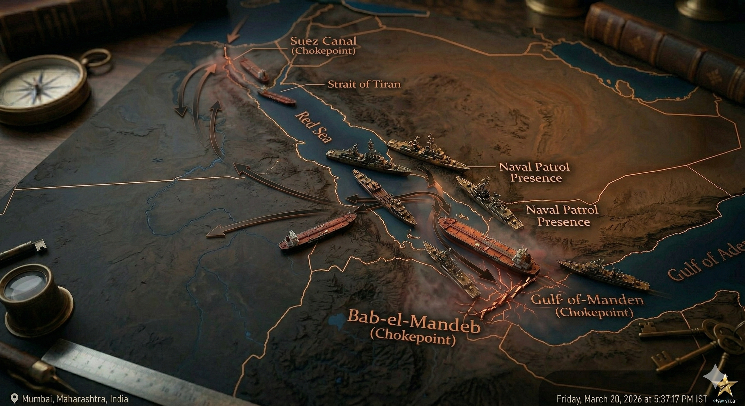
Bab El-Mandeb is in the southwestern part of the Yemeni coastline and extends its ports to the northern port of Midi. These ports are a strong naval force asset for the rebels since the outbreak of the civil war in 2015 and have been a source of danger for the transit of shipments, especially through the Red Sea enclave. With a hundred thousand people killed and another thousand injured, the country has been experiencing what is still today the world’s worst humanitarian crisis. Its political incapability to maintain the de facto control of the territory has opened the door for foreign intervention by a Saudi Arabian-led coalition to defeat the Houthis rebel faction threatening the government, which in turn is backed by Iran in its proxy war against Riyadh. But Sana’a is not only shaken by insurgent groups, as it also bears the burden of terrorist groups entrenched within its territory. The military bases positioned in the Strait have also allowed the United States and Saudi Arabia to fight terrorism in Yemen. Still, terrorist attacks against the government and Yemeni territories have been the order of the day, and the Strait has not been an exception, constituting the main source of geopolitical concerns in the region.
Likewise, piracy in neighbouring Somalia in the Horn of Africa also constitutes a direct source of instability in the region, and the conflict in Yemen has provided the breeding grounds for its perpetuation. The endemic corruption and political instability of the neighbouring African country of Djibouti do not help either, which, by reason of its size (around 950.000 inhabitants) and domestic limitations, is offered as an entry point for exploitation and profitability. Piracy assaults imply an additional source of threat to the Bab El-Mandeb chokepoint.
The Yemeni conflict worsens the stability of the corridor and feeds the grounds for piracy actions in the waterway. Even so, the volume of piracy attacks has been dramatically decreasing during the last years in the Strait (with only 9 incidents in the year 2018), according to The State of Maritime Piracy Report of 2018, mostly due to the global coalitions and organisations that have performed special missions to reduce these source of criminal activities, such as the Operation Atalanta, U.S-led NATO and the European Union have also played their role in counterterrorism and counter-piracy operations in the southeast zone of the Strait, such as the regional operation Ocean Shield. Similarly, countries such as Egypt are directly affected by threats to the Bab El-Mandeb Strait, as instability disrupts traffic through the Suez Canal and the Sumed pipeline. Therefore, Egypt, together with the other seven regional countries, led by Saudi Arabia, is working on a new regional alliance in the Red Sea to combat piracy and smuggling.
Financial Chokepoints: The Dollar and SWIFT
The Dollar
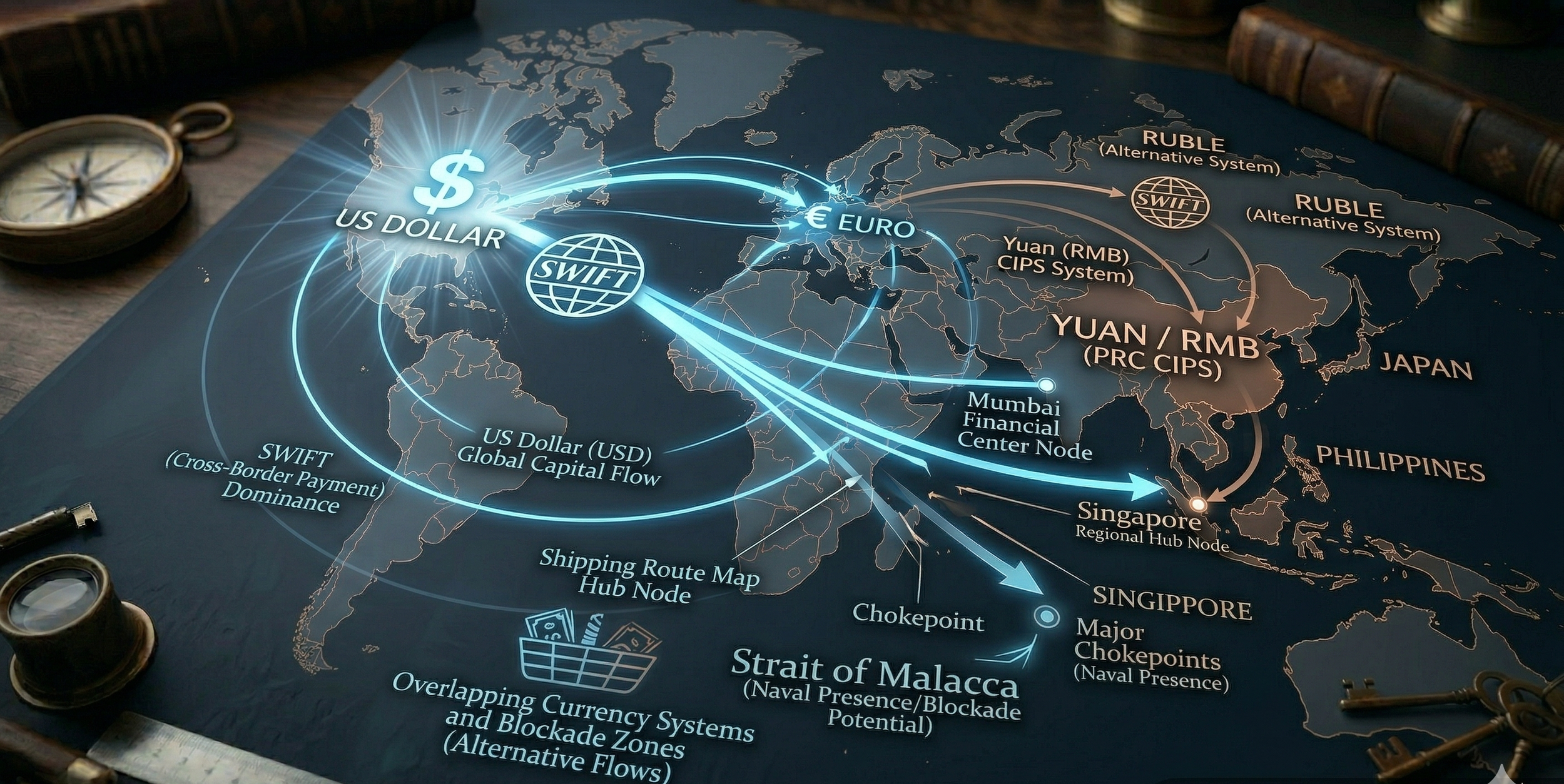
Before the 20th century, the British Pound Sterling was the global reserve currency due to Great Britain’s dominant position in global trade. However, after the two World Wars, the United States was the only major economy not completely devastated by the war. With the pound's overvaluation and subsequent decline, combined with the US holding most of the world’s gold reserves, the dollar continued to strengthen. At the 1944 Bretton Woods Conference, held to establish the post-war economic order, the United States officially became the global reserve currency, pegged to gold at $35 per ounce. When President Richard Nixon ended the dollar’s convertibility to gold in 1971, its value instead became pegged to a floating exchange rate backed by the full faith and credit of the US government. To this day, the USD remains the global reserve currency, in large part due to its deep, liquid financial markets, its use in global commodities trading (most notably oil), and—simply—because everyone else is trading in dollars, raising “switching costs.”
Most of the world’s central banks hold a significant portion of their foreign exchange reserves in US dollars to back their own currencies and service international debt. This “exorbitant privilege,” as first described by France’s financial minister in the 1960s, allows the US to borrow at lower interest rates than foreign central banks would otherwise allow. It also means that the US government and American firms can borrow money in USD rather than foreign currency, saving on transaction costs and making their loans less susceptible to exchange-rate fluctuations, which could otherwise increase foreign borrowers’ debt burdens. Currently, the dollar accounts for 56% of global foreign exchange reserves, 54% of export invoicing, and a staggering 89% of foreign exchange transactions.
SWIFT
Money and finance have been conceptualised as an infrastructure for the economy and for society. Finance has developed its own infrastructures, defined as ‘the socio-technical systems enabling basic yet crucial financial functions to be carried out, but that tends to be taken for granted and assumed’. As financial activities have become more complex and speculative, centralised ordering institutions such as central banks and financial infrastructures have evolved to smooth the conduct of finance and commerce across space and time. This chapter engages with SWIFT (Society for Worldwide Interbank Financial Telecommunication) as a long-standing, monopoly-like infrastructure. It employs a meso-level infrastructural gaze, showing interdependencies between micro-level, often backgrounded, socio-technical systems and processes, and macro-level concerns of legitimacy and power.
While many infrastructures store and transfer value, whether as money or as securities, SWIFT, and this is a key distinction, transfers data/information about value between banks and financial infrastructures internationally. SWIFT’s original role and raison d’être were to provide a secure, digital, international financial messaging system. A small group of Western banks started using SWIFT in the 1970s. Since then, it has expanded into messaging for post-trade securities transactions, which now accounts for a larger share of its messages than payments. It has also expanded its global membership to include financial actors beyond banks. It also offers shared services to its member financial institutions, such as payment reference data to ensure proper transaction routing and support for financial crime compliance, both of which all banks must meet.
In recent years, SWIFT has also become a geopolitical instrument, particularly as Western powers have leveraged access to it as part of sanctions regimes against states like Iran and Russia. The exclusion of targeted banks from SWIFT can successfully isolate them from global financial flows, imposing a high economic cost. Though geopolitical rivalries deepen, states subject to sanctions or seeking greater financial independence are exploring alternatives to SWIFT. Such efforts are not merely technical or inherently political but also reflect broader aspirations to reduce reliance on Western-dominated financial infrastructure and to assert greater autonomy in economic affairs.
One of the most consequential dimensions of SWIFT’s geopolitics is its function in enforcing and amplifying sanctions. Exclusion from SWIFT can isolate financial institutions from the global markets, making sanctions more effective. Alternatives that enable sanctioned actors to transact outside SWIFT’s reach could, in theory, dilute the impact of such measures. However, the actual effectiveness of sanctions evasion via alternative networks is mixed. The limited reach of many alternative systems implies that, even if a sanctioned party can communicate through a parallel infrastructure, its ability to clear payments and access liquidity remains constrained if counterparties outside the network are unwilling or unable to engage. Moreover, the emergence of alternatives may prompt recalibrations in the design and implementation of sanctions. Policymakers may seek to extend compliance requirements across multiple systems or develop mechanisms to monitor activity within alternative networks. This dynamic illustrates the iterative relationship between infrastructure expansion and regulatory strategy.
There has been a growing motivation to pursue alternatives to SWIFT as the desire for financial autonomy increases. States that experience sanctions or anticipate geopolitical tensions perceive reliance on a Western-dominated system as a vulnerability. For these actors, developing an independent messaging infrastructure functions not only as a technical workaround but also as a statement of sovereignty and strategic-level resilience. Russia’s SPFS, initiated after the 2014 sanctions following its annexation of Crimea, illustrates how geopolitical pressure catalyses efforts to insulate critical infrastructure.
While SPFS remains limited in international reach compared to SWIFT, it demonstrates a determined effort to reduce exposure to extraterritorial financial controls. Similarly, China’s CIPS represents both economic plus strategic ambitions. China’s Belt and Road Initiative and efforts to internationalise the renminbi require payment infrastructure capable of supporting cross-border transactions beyond US jurisdiction. CIPS operates alongside SWIFT, handling renminbi transactions and providing an alternative corridor for participating institutions. The expansion of CIPS is consistent with China’s broader push to assert leadership in the global financial system, challenging dollar dominance and creating space for diversified exchange mechanisms.
The geopolitics of SWIFT replacement illustrates the entanglement of infrastructure, power, and strategy in the global financial system. Efforts to develop alternatives are motivated by a combination of strategic geopolitical calculation, economic ambition, and technological opportunity. While alternatives like SPFS and CIPS present pathways to reduce dependence on Western-centric infrastructure, they face major challenges concerning scalability, interoperability, and adoption. The implications extend beyond technical considerations to encompass the effectiveness of sanctions regimes, the strength of financial networks, and the future shape of global finance.
With The Dollar and SWIFT combined, the USD's central role in the global economy also means that most international transactions must involve the USD at some point. That is immense leverage. The US Treasury Department’s Office of Foreign Assets Control has enormous power to impose economic sanctions, freeze foreign assets, monitor cross-border transactions, and remove adversaries from the SWIFT system. Examples include blocking the Russian Federation and affiliated firms from accessing frozen assets via the SWIFT system after the Russian invasion of Ukraine in 2022 or imposing foreign asset controls on Cuba in 1963. Economic sanctions backed by the USD reserve currency have surged ninefold over the past two decades, a sign of its power to compel foreign policy actions.
These chokepoints have become potent tools of economic warfare precisely because they can be used unilaterally and without military force. Just as air power transformed warfare by allowing states to inflict damage without incurring battlefield casualties, hyper-globalisation has enabled a more forceful form of economic coercion that operates below the threshold of armed conflict.
The New Battlefield: Economic and Strategic Pressure
In the modern geopolitical landscape, power is no longer exercised solely through armies and land acquisition—it is increasingly wielded through economics, infrastructure, and control over global systems. Geography still matters, but its influence has evolved. Strategic chokepoints, trade routes, and resource corridors have become instruments of pressure, allowing states to project power without ever firing a shot. This shift marks the rise of economic statecraft, in which influence is measured not just by military capability but also by the ability to disrupt, control, or redirect the flow of global commerce.
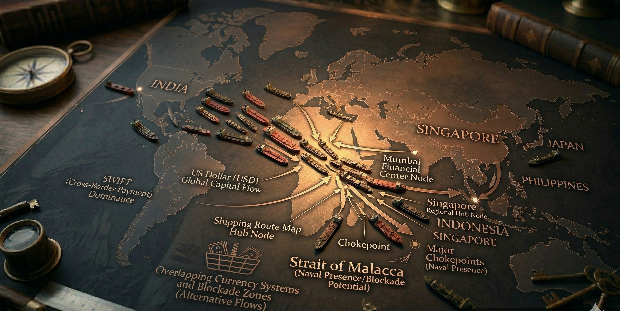
Supply chains now serve as both essential lifelines and sources of vulnerability. The interconnected networks that drive globalisation can be weaponised during periods of tension. Disruptions in critical maritime routes or restrictions on key exports, such as semiconductors, rare earth elements, or energy resources, can produce cascading effects across continents. Recent global crises have highlighted these weaknesses. Nations are no longer merely competing for resources; they are competing for control over the systems that distribute them. In this context, geography serves as a lever, with ports, straits, and logistical hubs as pressure points that can determine global outcomes.
Trade wars have further blurred the line between cooperation and conflict. Tariffs, sanctions, and export controls have replaced traditional battlefields with economic arenas. Major powers engage in prolonged strategic competition, targeting industries, technologies, and financial systems rather than territory alone. This form of indirect conflict is less visible, but often more enduring. It allows states to weaken rivals over time while continuing plausible deniability and avoiding the immediate costs of open warfare.
At the same time, the dominance of the global financial system—particularly the role of the US dollar—has become a central point of contention. Efforts toward de-dollarisation reflect a broader desire among nations to reduce dependence on a system that can be leveraged as a geopolitical tool. Alternative payment mechanisms, bilateral trade agreements in local currencies, and regional financial architectures are slowly emerging, signalling a change in how economic power is structured and contested.
What emerges is a new kind of battlefield—one defined not by borders, but by flows. Flows of goods, energy, capital, and information. In this world, control over geography does not just determine who moves—but who decides who can move at all.
Power in Narrow Spaces
For all the language of global dominance, the world is not controlled everywhere at once. Power does not stretch evenly across the map. It concentrates. It tightens around a handful of narrow seas, mountain corridors, pipelines, ports, rail junctions, canals, and straits—places that appear small in scale yet hold consequences far larger than their geography suggests. These are the points where the movement of oil, food, weapons, data, and trade converges. And because so much of the modern world depends on uninterrupted flow, control over these spaces frequently matters more than control over vast land itself.
This is the quiet logic of geopolitics: empires may speak in terms of ideology, military strength, or economic vision, but still, beneath all of it lies access. Access to routes. Access to markets. Access to energy. Access to oceans. The map still decides more than leaders like to admit. A narrow waterway can shape the fate of continents. A blocked canal can shake markets worldwide. A vulnerable chokepoint can turn prosperity into panic almost overnight. What seems stable is often just the temporary condition of everything continuing to pass through a few fragile passages without interruption.
That is what makes these spaces so dangerous. They are not merely strategic—they are exposed. Fragile. Difficult to replace. When pressure builds between great powers, these routes become more than transit lines; they become leverage. A threat does not need to become a war to be effective. It only needs to suggest an interruption. Delay. Restriction. Vulnerability. In a world founded on speed and interdependence, even the possibility of disruption may become a weapon.
So, the real architecture of global power may not lie solely in capitals, speeches, or even armies. It lies in the narrow spaces where geography compresses movement and turns location into influence. The future of global power may not be decided on battlefields, but in the narrow spaces where everything must pass. And that is what makes the modern world so uneasy: for all its scale, all its technology, and all its claims of toughness, so much still depends on passages thin enough to break.
References
Aguilera Raga, A. (2020). The Bab El-Mandeb Strait: Geopolitical considerations of the Strategic Chokepoint. JSTOR.
Akram, Q., & Fareed, M. (2019). China’s Malacca Dilemma: Power politics in Indian Ocean. In Department of International Relations, Kinnaird College for Women, Lahore & M. Phil Scholar, Kinnaird College for Women, Lahore, Journal of Politics and International Studies: Vol. Vol. 5 (Issue No. 2, pp. 29–44) [Journal Article].
Alexandre, A. G. (2021). The Strait of Bab El-Mandeb: stage of geopolitical disputes. JANUS NET E-journal of International Relation, 12(2). https://doi.org/10.26619/1647-7251.12.2.5
AN. (2024). Strategic importance of Strait of Malacca in Southern Asia. https://www.ankasam.org/strategic-importance-of-strait-of-malacca-in. . .
Berrocal Menarguez, A. B., & Pous De La Flor, J. (2017). The new Panama canal. In Case Study of Innovative Projects - Successful Real Cases. http://www.intechopen.com/books/case-study-of-innovative-projects-successful-real-cases
Blockage of the Suez Canal, March 2021 | Port Economics, Management and Policy. (2025, May 2). Port Economics, Management and Policy | a Comprehensive Analysis of the Port Industry. https://porteconomicsmanagement.org/pemp/contents/part10/port-resilience/suez-canal-blockage-2021/
Carse, A., Middleton, T., Cons, J., Dua, J., Valdivia, G., & Dunn, E. C. (2020). Chokepoints: Anthropologies of the Constricted Contemporary. Ethnos, 88(2), 193–203. https://doi.org/10.1080/00141844.2019.1696862
Cuffe, H. (2021). THE SUEZ CANAL: ITS HISTORY AND SIGNIFICANCE. JSTOR, Issue 4. https://www.suezcanal.gov.eg/English/About/SuezCanal/Pages/AboutSuezCanal.aspx
Datenbank-Informationsdienst Michael Klems. (2026, March 10). The Panama Canal: global trade bottleneck, engineering marvel and climate risk. infobroker.de Research Services. https://www.infobrokerworld.com/the-panama-canal-global-trade-bottleneck-engineering-marvel-and-climate-risk/
Global Institute Dialogues: Edward Fishman on Economic chokepoints. (2026, January 16). Goldman Sachs. https://www.goldmansachs.com/what-we-do/goldman-sachs-global-institute/articles/edward-fishman-on-economic-chokepoints
Gorgas, W. & Library of Congress. (n.d.). The Panama Canal: A Study on Lock-Based Operating Mechanisms and Economic Contributions. The Panama Canal.
Harrison, J. A., Rodriguez, L. M., Nguyen, C. T., Carter, M. B., & Cole, J. (n.d.). Geopolitics of SWIFT Replacement. JSTOR.
Hiep, T. X., & Binh, N. T. (2020). THE STRAIT OF MALACCA (MALAYSIA) WITH ITS ROLE IN THE NETWORK OF MARITIME TRADE IN ASIA AND EAST – WEST CULTURAL EXCHANGE IN THE MIDDLE AGES [Journal-article]. Palarch’s Journal of Archaeology of Egypt/Egyptology, 17–4, 84–92.
Johns, W. E., Sofianos, S. S., Division of Meteorology and Physical Oceanography, Rosenstiel School of Marine and Atmospheric Science, University of Miami, Miami, Florida, & Division of Environmental Physics, University of Athens, Athens, Greece. (2012). Atmospherically Forced Exchange through the Bab el Mandeb Strait. In Journal of Physical Oceanography (Vol. 42, p. 1143) [Journal-article]. https://doi.org/10.1175/JPO-D-11-0157.1
Kaplan, R. D. & David Lindroth, Inc. (2012). The revenge of geography : what the map tells us about coming conflicts and the battle against fate. Random House, Inc.
Kenawy, E. & Kafr El-Sheikh University, Egypt. (2016). The economic impacts of the New Suez Canal. Panorama, 283.
Labh, N. (2025). Chokepoint politics and the reordering of global trade. the SAIS Review of International Affairs, 45(2), 37–48. https://doi.org/10.1353/sais.2025.a984724
Marshall, T. (2015). Prisoners of geography. In Prisoners of Geography [Book].
Meza, A., Ari, I., Sada, M. A., & Koç, M. (2022). Disruption of maritime trade chokepoints and the global LNG trade: An agent-based modeling approach. Maritime Transport Research, 3, 100071. https://doi.org/10.1016/j.martra.2022.100071
Moulton, C. (2026, March 20). What is the Strait of Hormuz, and why does it matter? Northeastern Global News. https://news.northeastern.edu/2026/03/19/what-is-the-straight-of-hormuz/
Olson, K. R., & Chernyanskii, S. S. (2025). Historical, economical and environmental impacts of Suez Canal connecting the Mediterranean Sea and Red Sea. Journal of Water Resource and Protection, 17(02), 68–95. https://doi.org/10.4236/jwarp.2025.172005
Pandolfini, V. (2020). International Journal of Research and Innovation in Social Science. International Journal of Research and Innovation in Social Science. https://doi.org/10.47772/ijriss
Pineda, G. (n.d.). The Strait of Malacca as one of the most important geopolitical regions for the People’s Republic of China.
Robinson, G., Jr., Dörry, S., & Derudder, B. (2023). SWIFT: Trusted infrastructure for infrastructures. In SWIFT (pp. 237–239). Cambridge University Press. https://doi.org/10.1017/9781009428118.022
Scott, S. V., & Zachariadis, M. (2012). Origins and Development of SWIFT, 1973–2009 [Article]. Business History, 3, 462–482. https://doi.org/10.1080/00076791.2011.638502
Sierocińska, K. (2017). The Panama Canal as a factor of Panama’s economic growth. Estudios Latinoamericanos, 37, 297–310. https://doi.org/10.36447/estudios2017.v36-37.art13
Sikhosana, S., Lephethe Motsepe, H., & Sikhosana, S. (2025). FROM SWIFT TO SOVEREIGNTY: GEOPOLITICAL DRIVERS OF FINANCIAL MESSAGING ALTERNATIVES. International Journal Research Publication Analysis, 01(06), 1–18. https://doi-doi.org/101555/ijrpa.8962
Soffer, A. (2023). The Impact of the Suez Canal on Egypt’s geography and Economy, 1867–2019 (150 years since its opening). In Palgrave studies in maritime politics and security (pp. 181–198). https://doi.org/10.1007/978-3-031-15670-0_9
Spanier, B. (2023). Freedom of navigation in the Suez Canal and the Channels: Law of the Sea. In Palgrave studies in maritime politics and security (pp. 117–133). https://doi.org/10.1007/978-3-031-15670-0_6
Stavridis, J., USN (Ret. ). (2017). Sea power : the history and geopolitics of the world’s oceans. In PENGUIN PRESS & Penguin Random House LLC, Penguin Press [Book]. Penguin Press. http://bit.ly/2qgp0p2
Tan, N. (2026, February 8). BLUF #12: Dollar Dominance, Dollar Downfall, Dollar Domino. Rules of Engagement. https://www.roemedia.org/p/bluf-12-dollar-dominance-dollar-downfall
Twomey, A., Jr., Twomey, K., Twomey, A., Twomey, R., & Twomey, J. (n.d.). A few interesting Suez Canal facts. A Few Interesting Suez Canal Facts, 1–5. https://www.nauticalhistory.net/pdfs/A%20Short%20History%20of%20the%20Suez%20Canal.pdf
WITA. (2026, March 13). Oil, power, and the dollar - WITA. https://www.wita.org/blogs/oil-power-and-the-dollar/#:~:text=Across%20these%20examples%2C%20a%20pattern,meant%20influence%20over%20capital%20flows.
Youvan, D. C. (2024). Navigating Troubled Waters: The strategic importance of the Suez Canal and Red Sea in global maritime trade. JSTOR.
Zaouaq, K. (2018). The Bab El-Mandeb Strait: a threatened strategic passage. JSTOR. https://www.moroccoworldnews.com/2018/08/252041/bab-el-mandeb-strait-strategic-passage/